
SAN ANGELO, TX - The National Weather Service in San Angelo has forecast a multi-day period of thunderstorms across West Central Texas, with isolated to scattered severe storms possible starting Wednesday, March 4, 2026, and continuing through the weekend.
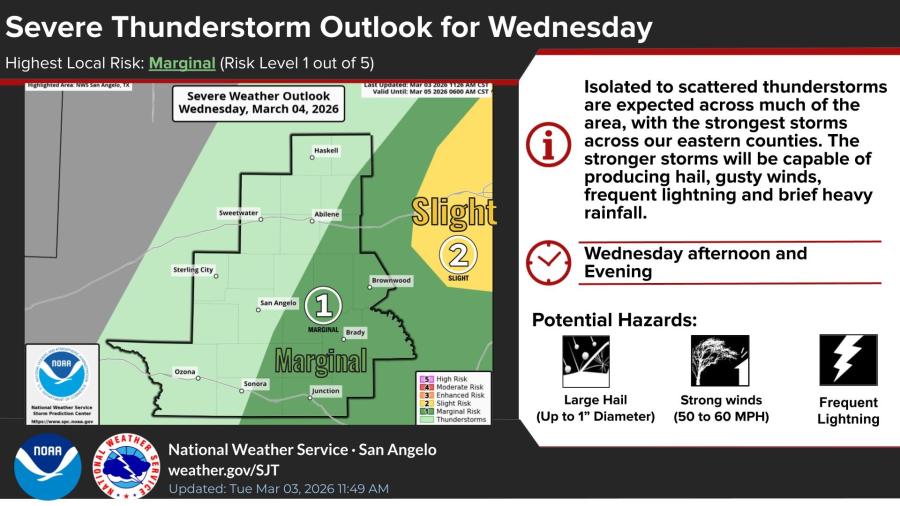
For Wednesday, the NWS San Angelo office highlights a marginal risk (level 1 out of 5) of severe thunderstorms, primarily in eastern counties such as those near Abilene, Brownwood, Haskell, and Brownwood. Isolated to scattered thunderstorms are expected across much of the forecast area in the afternoon and evening, with the strongest storms capable of producing hail up to 1 inch in diameter, gusty winds of 50-60 mph, frequent lightning, and brief heavy rainfall.
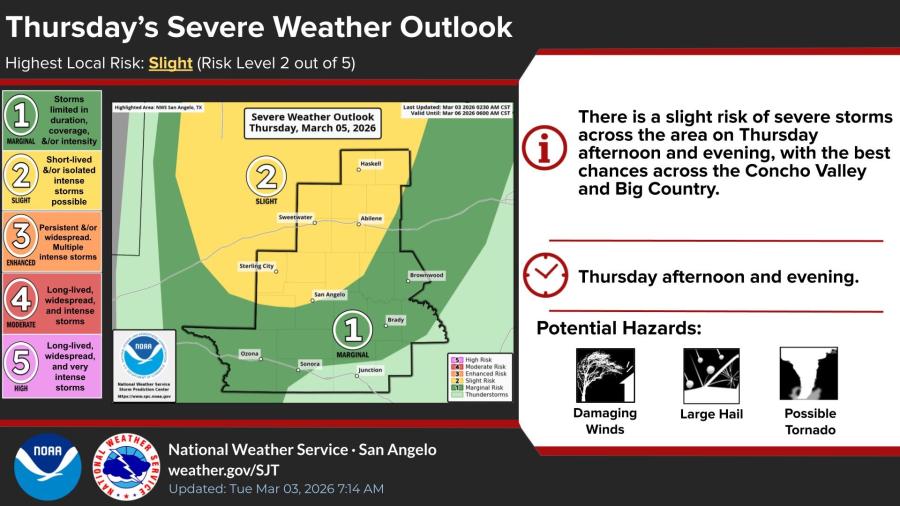
Thursday carries a higher slight risk (level 2 out of 5), with storms possible across the Concho Valley and Big Country during the afternoon and evening. Threats include large hail, damaging winds, frequent lightning, and isolated tornadoes.
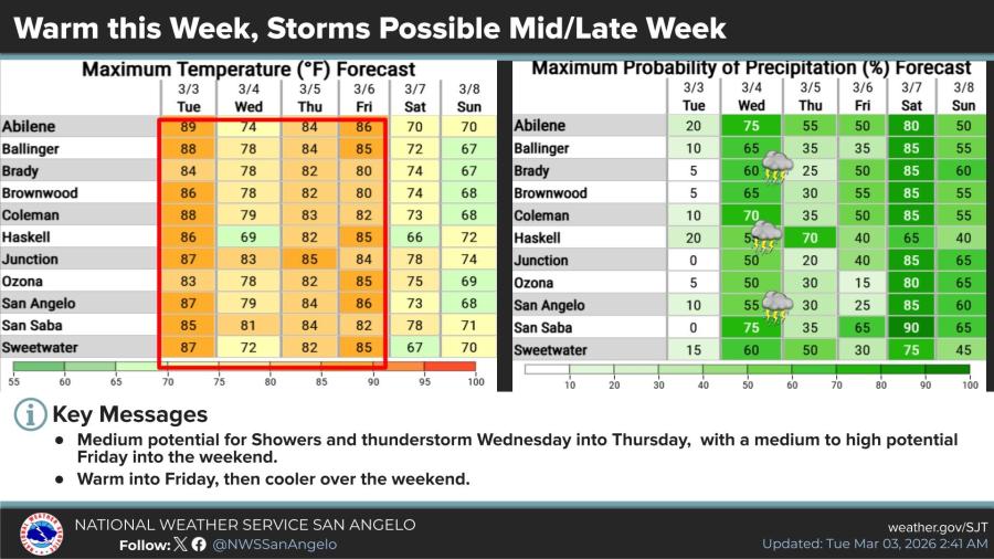
Temperatures will remain warm through Friday, with highs in the mid- to upper 80s across locations like San Angelo (87°F Tuesday, dropping to 79°F Wednesday, then back to 84°F Thursday and 86°F Friday). Precipitation chances rise significantly: 55-75% in many areas Wednesday, 25-70% Thursday, and increasing again Friday into the weekend.
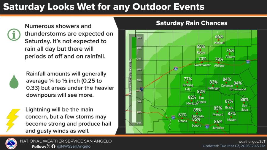
Saturday looks particularly wet, with numerous showers and thunderstorms expected across the region. Precipitation chances reach 65-90% in spots like San Angelo (82%), Abilene (around 78-84% in nearby areas), and higher in eastern zones. Rainfall totals will generally average 0.25 to 0.33 inches, though heavier downpours could produce more. Lightning remains the primary concern, but some storms may produce hail and gusty winds.
The pattern stems from a cold frontal passage combined with upper-level disturbances mid-week, followed by another low-pressure system influencing the area later. The NWS notes medium to high potential for showers and thunderstorms from Wednesday into the weekend, with cooler conditions arriving over the weekend.
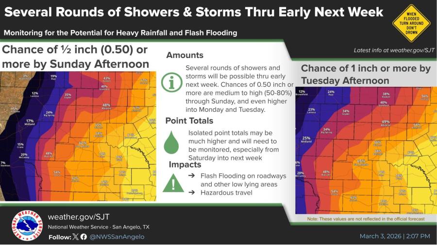
UPDATE: With multiple rounds of showers and storms for the weekend into next week across the area possible, the chances for some decent rainfall totals continues to increase. There is a medium to high chance (50-80%) of at least 1/2 inch (0.50) across the area by Sunday afternoon, and a medium to high chance (also 50-80%) of at least 1 inch by Tuesday afternoon.
Individual thunderstorms will produce even higher totals and will need to be watched closely for the potential for rainfall heavy enough to produce some areas of flooding.


Subscribe to the LIVE! Daily

Required
Post a comment to this article here: