
SAN ANGELO, TX — Showers and a few thunderstorms continued across the eastern part of the region late Thursday afternoon, with the National Weather Service warning at 4:05 p.m. that pockets of moderate to briefly heavy rain could still cause minor flooding east of a line from Albany to Clyde to Eden to Junction.
Forecasters said an outflow boundary moving east will bring strong west winds behind it, with gusts between 40 and 50 mph capable of blowing around loose objects, knocking down small tree limbs and kicking up blowing dust.
Updated rainfall totals released earlier Thursday afternoon show several locations surpassing 5 to 7 inches as storms continued moving across the region. The National Weather Service reported 7.04 inches in Menard, 6.32 inches in eastern Sutton County along I-10, 5.43 inches northeast of Menard, and 5.22 inches west-northwest of Junction. Melvin recorded 4.93 inches, while sites in Lohn, Shields, Winchell and Doole reported between 2.8 and 4 inches. Forecasters said additional showers and storms will continue to push these totals higher through the evening.
A flash flood emergency was issued for the Menard area at about 2 p.m.
In San Angelo, early totals remained lower than the hardest-hit areas to the east and south. The National Weather Service reported 0.98 inches at the Angelo State University Mesonet site and 1.26 inches at the San Angelo Regional Airport as of Thursday morning.
The National Weather Service says another round of showers and thunderstorms is expected this weekend, with rain chances increasing again late Saturday into Sunday. Sunday carries an 80% chance of showers and a possible thunderstorm, with new rainfall amounts between a half and three-quarters of an inch possible.
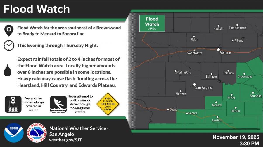
A Flood Watch remains in effect southeast of a Brownwood–to–Brady–to–Menard–to–Sonora line through Thursday night. Forecasters expected 2 to 4 inches of rain across the watch area, with isolated totals over 8 inches in some spots.
Clearer weather is expected Friday, with mostly sunny conditions and a high near 73. Rain chances return Saturday night into Sunday before another period of sunshine early next week.
View live radar HERE.


Subscribe to the LIVE! Daily

Required
Post a comment to this article here: