
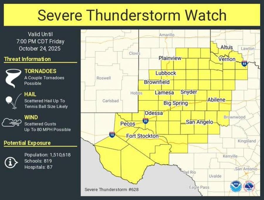
SAN ANGELO, TX — The National Weather Service has issued a Severe Thunderstorm Watch for much of West Texas, including Tom Green County, effective until 7 p.m. Friday, Oct. 24.
Counties under the watch include Tom Green, Coke, Concho, Runnels, Irion, Schleicher, Sterling, Crockett, and Reagan, along with more than 60 others across the region stretching from Lubbock to Midland, Abilene, and the Big Country.
According to the NWS San Angelo office, storms are expected to develop this evening, moving in from the west and northwest before spreading south and east through the night. The earliest storms could begin around 4 p.m. in far western counties, with the most likely window for severe weather between 5 p.m. and midnight. Storms should end by around 2 a.m. Saturday.
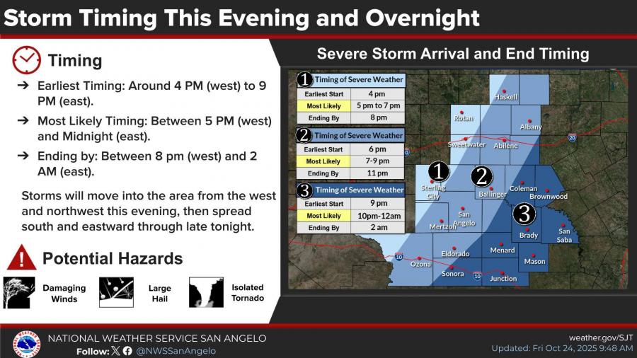
San Angelo and Abilene are expected to see storm activity between 6 and 9 p.m., with the line moving toward the Hill Country and Heartland between 9 p.m. and midnight.
Potential Hazards
The National Weather Service warns that storms could produce:
-
Damaging winds
-
Large hail
-
Isolated tornadoes
TEXAS COUNTIES INCLUDED ARE:
- ANDREWS
- ARCHER
- BAYLOR
- BORDEN
- BREWSTER
- BRISCOE
- CALLAHAN
- CHILDRESS
- COKE
- COLEMAN
- CONCHO
- COTTLE
- CRANE
- CROCKETT
- CROSBY
- DAWSON
- DICKENS
- ECTOR
- FISHER
- FLOYD
- FOARD
- GAINES
- GARZA
- GLASSCOCK
- HALE
- HALL
- HARDEMAN
- HASKELL
- HOCKLEY
- HOWARD
- IRION
- JEFF DAVIS
- JONES
- KENT
- KING
- KNOX
- LOVING
- LUBBOCK
- LYNN
- MARTIN
- MIDLAND
- MITCHELL
- MOTLEY
- NOLAN
- PECOS
- PRESIDIO
- REAGAN
- REEVES
- RUNNELS
- SCHLEICHER
- SCURRY
- SHACKELFORD
- STERLING
- STONEWALL
- TAYLOR
- TERRELL
- TERRY
- THROCKMORTON
- TOM GREEN
- UPTON
- WARD
- WICHITA
- WILBARGER
- WINKLER
- YOAKUM


Subscribe to the LIVE! Daily

Required
Post a comment to this article here: