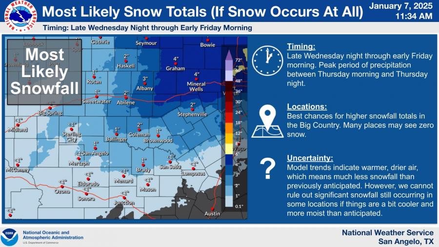
SAN ANGELO, TX - The National Weather Service in San Angelo has lowered projected snowfall totals for West Central Texas but stated that the chance of wintry precipitation is not entirely ruled out.
Updated models indicate significantly less snow for many areas, but some forecasts still show potential for accumulation in isolated locations.

Peak snowfall, if it occurs, is expected late Wednesday night through early Friday morning, with the highest chances in the Big Country. Current estimates suggest 1-2 inches of snow near Abilene, while San Angelo is forecast to receive less than an inch or none at all. The NWS noted that uncertainty in the forecast has increased considerably due to changes in weather models.
The shifting forecast stems from a Pacific storm system developing farther south than expected, leading to warmer and drier conditions across the region. While significant snowfall appears less likely, localized areas may still experience freezing precipitation, including sleet or freezing rain.
“We are NOT saying the chance of wintry precipitation is zero,” the NWS stated. “There are still some models showing decent snow totals, but they have become the minority. We are trending numbers down on the ‘most likely’ totals while emphasizing the growing uncertainty.”
For road conditions, contact TxDOT at 1-800-452-9292 or visit DriveTexas.org.
Subscribe to the LIVE! Daily
Required


Comments
Listed By: Wiley Coyote
Thats good news considering bonehead drivers out here.
They can keep it up north where it belongs.
- Log in or register to post comments
PermalinkPost a comment to this article here: